
by Judith Curry
Cat 5 Hurricane Irma is one for the record books; it’s eye is on Florida.
___________
Summary
- Major Hurricane Irma is predicted to strike the SW coast of Florida as a Cat 4 early Sun a.m., with a northward track covering the entire length of the state and into Georgia
- We’ve been monitoring this storm for two weeks, since the wave emerged from Africa. Irma developed and intensified to Major Hurricane (Cat 3) in the central Atlantic, over relatively cool ocean temperatures of 26.5C
- ECMWF has been on target so far with the predicted tracks, with CFAN’s calibrations providing considerable value
- Florida is exceptionally well prepared for Irma, lets see this plays out
- And finally, my take on the link between hurricanes and global warming: hurricanes are too complex to be explained by the simple thermodynamic reasoning that I heard from climate scientists following Hurricane Harvey
___________
Well, the 12 year drought of major hurricane landfalls in the U.S. is ending with a vengeance in 2017. Following the devastation in Texas by Hurricane Harvey, Hurricane Irma is bearing down on Florida. Landfall is expected this weekend. This blog post provides forecast history for Irma, and the latest predictions from my company, Climate Forecast Application Network (CFAN). And finally, I address the debate on the link between hurricanes and global warming.
Genesis of Irma
On 8/25, we began monitoring an African Easterly wave that was expected to form and was showing some early signs of developing into a tropical cyclone.
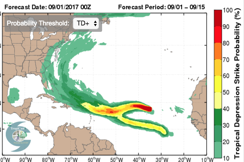
The National Hurricane Center (NHC) issued an invest on 8/28. The plot below shows an early forecast from CFAN, showing CFAN’s calibrated tracks and intensities for the ECWMF deterministic (red) and the ensemble mean (black). The NOAA GFS ensemble forecast was similar.

Irma became a named storm on 8/30. By 8/30, the tracks for the ECMWF model were shifting closer to Florida

CFAN’s calibrated probability distribution of tracks on 8/30 showed: 38% of the tracks in the Gulf of Mexico for ECMWF, and 23% of the tracks from NOAA GEFS in the Gulf of Mexico.
Intensification
Irma became a hurricane on 8/31. CFAN’s calibrated track probabilities are shown below for ECMWF (top) and NOAA GEFS (bottom).


For reference, the sea surface temperatures (ECMWF operational analysis) is shown below. Irma formed where SST was about 80F (26.5C).

In a matter of a few hours, Irma became a major hurricane. The surprising thing about this development into a major hurricane was that it developed over relatively cool waters in the Atlantic – 26.5C — the rule of thumb is 28.5C for a major hurricane (and that threshold has been inching higher in recent years). On 8/31, all the models were predicting a major hurricane to develop, with some hints of a Cat 5.
So why did Irma develop into a major hurricane? We can’t blame 26.5 C temperatures in the mid Atlantic on global warming.
The dynamical situation for Irma was unusually favorable. In particular, the wind shear was very weak.


Further, the circulation field (e.g. stretching deformation) was very favorable for spinning up this hurricane.
Irma intensified to Cat 5 on 9/5. This intensification was picked up by the models on 8/31, but at this point it was mostly a case of ‘right answer for the wrong reason’, since the models hadn’t yet settled down regarding track.
Astonishingly, Irma has hung on to its Cat 5 status through the time of this writing.
Zeroing in on the track
The track forecast for Irma has been challenging because of:
- a predicted sharp northward turn in the Caribbean
- FL is challenging target for a northward moving tropical cyclone, because of its geography as a peninsula
A Florida landfall has been the favored prediction from CFAN’s calibrated ECMWF tracks since 9/03:

The NHC models have vacillated a bit more – in the diagram below, focus on the GFS (blue), HWRF (orange), HMON (green).

The value add of CFAN’s track calibration and Monte Carlo resampling technique is particularly evident in the earlier ECMWF track forecasts:
CFAN’s calibrated ECMWF tracks with Monte-Carlo resampling
Raw ECMWF
Several interesting analyses re Irma’s track forecast biases:

Landfall impacts
At the time of this post, Irma’s intensity has dropped to Cat 4 after an eyewall replacement cycle.
Here is CFAN’s latest cone of uncertainty for ECMWF (top) and NOAA GEFS (bottom):

Here is CFAN’s high predictability cluster from ECMWF (red is deterministic, bold black is ensemble mean):

Here are the latest tracks from NHC (blue is GFS, green is HMON, orange is HWRF)

An image from CFAN’s new zoomable landfall impact tool:

Here is max wind speed plot for Florida, based on CFAN’s calibrated winds from ECMWF DET:
 Here is an estimate of the storm surge from Irma (fortunately landfall on Sunday around 2 am will be low tide):

The worst case scenario for South Florida isn’t what happened with Andrew. It’s what happened during the 1920s, with massive flooding of Lake Okeechobee. The Herbert Hoover Dike was built to ameliorate this, but the NHC is warning of a possible breach to the dike.
Global warming
Ever since Hurricane Harvey, the global warming – hurricane hysteria has ratcheted up to levels I haven’t seen since 2006.
NOAA GFDL has written a good article on Global Warming and Hurricanes. Their main conclusions:
- It is premature to conclude that human activities–and particularly greenhouse gas emissions that cause global warming–have already had a detectable impact on Atlantic hurricane or global tropical cyclone activity. That said, human activities may have already caused changes that are not yet detectable due to the small magnitude of the changes or observational limitations, or are not yet confidently modeled (e.g., aerosol effects on regional climate).
- Anthropogenic warming by the end of the 21st century will likely cause tropical cyclones globally to be more intense on average (by 2 to 11% according to model projections for an IPCC A1B scenario). This change would imply an even larger percentage increase in the destructive potential per storm, assuming no reduction in storm size.
- There are better than even odds that anthropogenic warming over the next century will lead to an increase in the occurrence of very intense tropical cyclone in some basins–an increase that would be substantially larger in percentage terms than the 2-11% increase in the average storm intensity. This increase in intense storm occurrence is projected despite a likely decrease (or little change) in the global numbers of all tropical cyclones.
- Anthropogenic warming by the end of the 21st century will likely cause tropical cyclones to have substantially higher rainfall rates than present-day ones, with a model-projected increase of about 10-15% for rainfall rates averaged within about 100 km of the storm center.
I agree wholeheartedly with #1. I agree qualitatively with 2-4, but GFDL has much greater faith in the climate models than I do (and of course the 21st century projections assume substantial warming, which I don’t necessarily agree with). However, I much prefer their model-based quantitative estimates (but they need some serious uncertainty estimates, including structural uncertainty), relative to hysterical arm waving by Mann and Trenberth using undergraduate basic thermodynamics reasoning. There is nothing basic or simple about hurricanes.
I include this text from my 2010 post Hurricane Katrina – 5 years later, particularly relevant given the cool SST values that Irma formed and intensified.
The relationship between sea surface temperature and hurricane intensity. The causal chain for global warming to increase hurricane intensity has been argued to occur via the increase in sea surface temperature (SST) (e.g. Curry et al. 2006 ). A nominal SST threshold of 26.5-27oC is used as a criterion for tropical cyclogenesis, and a nominal threshold of 28.5oC for intensification to a major hurricane. Some new insights into the relationship between a warming climate and hurricane intensity is suggested by Hoyos and Webster (2010, forthcoming). During the latter half of the 20th century, the tropical warm pool defined by the isotherm of 28oC has expanded in area. However, the region of tropical cyclogenesis has not expanded, owing to the area of convective activity remaining nearly constant. Hoyos and Webster argue that the temperature threshold for tropical cyclogenesis increases as the average tropical ocean temperature increases. It is the increasing intensity of the convection with warmer temperatures that seems to be the link between SST increase and hurricane intensity, rather than the absolute value of the SST itself. Further, the location of the intense convection is related to the difference between the local SST and global tropical average SST, rather than to the absolute value of the SST itself (Vecchi et al. 2008)
This is particularly relevant for interpretating the formation of extremely strong hurricanes in the early half of the 20th century, when SSTs were significantly cooler.
At some point, probably in the 2020’s, the Atlantic Multidecadal Oscillation (AMO) will flip to the cool phase (which typically lasts several decades), which is associated with low Atlantic hurricane activity. At this point, natural variability (interannual, decadal, multi-decadal) is swamping any potential signal of global warming on hurricanes.
After I wrote the above article, I spotted this article by Chris Mooney: The science behind the strange hurricane ‘drought’ — and its sudden end. This para illustrates the level of disagreement and faulty reasoning on this whole topic:
“A debate continues about why the 1970s and 80s were relatively quiet in the Atlantic,” said MIT hurricane researcher Kerry Emanuel. “Some believe that it was the consequence of a natural climate oscillation called the Atlantic Multi-decadal Oscillation (AMO), while others, including me, think is was mostly a consequence of sulfate aerosol pollution.”
IMO, the arguments supporting the aerosol theory don’t hold up. The IPCC AR5 and more recent research, showing that sulfate aerosol forcing of climate (generally, and also mid 20th century) is much smaller than thought circa the AR4. Not to mention the massive amounts of sulfate being emitted by Asia in recent decades.
p.s. Cliff Mass has a new blog post Global Warming and Hurricane Harvey, well worth reading.
Florida preparedness
In contrast with Texas, Florida is massively prepared for hurricanes, with strict building codes, emergency management procedures, and comprehensive procedures to rapidly restore electric power.
That said, this is the biggest and baddest landfall strike in the U.S. in a long time. Irma is worse than Andrew (1992) and Wilma (2005), which were also Cat 5; Irma has a large horizontal extent, which means larger swath of hurricane force winds, bigger storm surge, more rainfall and tornadoes.
Lets see how it plays out, but I anticipate that this will go much better than Hurricane Harvey and Houston.
I’ve been talking with Floridians that remember Andrew (1992). I reminded them how MUCH better the forecast information is now, relative to 1992.
Apart from Florida, Georgia and the Carolinas are also facing impacts from Irma. Atlanta could see hurricane force winds! From a massive storm like this, there will be perhaps a hundred tornadoes generated inland, mostly in the right forward quadrant of the storm.
Operational notes
Huge thanks and acknowledgements to CFAN’s Jesse Marks, Violeta Toma and our software engineers for sleepless nights and doing a tremendous job in ensuring the timely delivery of our forecast products in this very challenging operational environment. I will need to dish out some good bonuses in their September pay checks.
Stay safe everyone!

“it’s eye is on Florida.”
its, not it’s
I’m new here and new to the ideas of Professor Curry. I could certainly be wrong, however, from what little information I’ve gathered so far on the Professor’s views she seems to be of the opinion that the climate debate has become “too politicized” and has strayed away from good scientific practice. If such is the case, then my question is; what is meant by “politicization” in her sense? I mean, if allegedly overzealous climate scientists are being too political, then what does the professor think of large corporate interests in the energy industry that seem to be pretty busy lobbying policy makers to uphold their interests and those of their investors? Do they pose a problem as well, a conflict of interest, or is it just climate scientists that pose a problem for whatever “selfish” reasons (presumably because they seem to bear bad news for fossil fuel interests)?
Also from what I gather, the professor is in agreement that the climate is warming and that human activities are likely contributing to the warming to at least some limited extent. Wouldn’t that be good reason to encourage the use of more environmentally sustainable energy? Is there any harm in making a concerted effort to switch over from fossil fuels to cleaner energy sources? I just wonder if the professor’s crusade to uphold whatever etiquette in the climate debate is a prudent one. Is this a time to worry about etiquette and “polite” conversation when so much could potentially be at stake? It seems like a large portion of the voting population in America has embraced “climate skepticism”, enough to seriously hinder any effective action on what so many scientists seem to consider an extremely dire situation unfolding. What more does Professor Curry want from the public? Shouldn’t she be out giving more talks on how pursuing sustainable energy is the best course of action? Are we all at least in agreement on a need to pursue more environmentally sustainable energy?
Thanks for any enlightenment on this issue.
No.
Come on Charles you are being even more gnomic than mosh
Tonyb
If you don’t think the climate debate has become too politicized, then you would not agree Trump has done more to harm carbon mitigation with his policy positions than help. You also would not agree Trump is
a climate change denier white male republican with an anti-science fossil fuel agenda. If the climate debate were not too politicized, you wouldn’t agree those are two politicized positions in the climate debate many/most climate scientists would agree with and share. I provide no links to substantiate that claim. However, I would challenge you to substantiate that claim is false.
Ironically I read, see and hear all the time in the news how those concerned with climate change are teaming up, banding together, and coalescing to combat Trumps policies, moving ahead with more renewables and pledging more carbon cuts in the future beyond the Paris Accord in response to Mr Trump. Huh, go figure. No additional federal regulation needed for elected officials to act on their own at the local and state government level to address their climate change concerns. Many forward thinking large corporations, without any federal intervention, are conscientiously taking on sustainable energy initiatives to lower thier carbon footprint all on their own. Many as a direct response to Mr Trumps anti-science policy positions on climate change
Mr Trump has single handedly promoted more calls to action to curb carbon emissions than Mr Obama ever did by just taking a position that climate change is no big deal. Judy’s concerns, though worthy of consideration, have become a footnote to the larger political and social picture evolving in this country.
“”Once you understand the scientific uncertainties, the present policy path that we’re on doesn’t make a lot of sense,” she said.”
This is only one quote of hers.
In your example, you have climate scientists and corporations both speaking. The corporations aren’t scientists. Dangerous climate change is a subject for the voters to decide. So we still have the question of, if climate scientists should be political? Policy responses are not what their degrees are in. However, climate economists may have a better standing.
The costs of wind and solar when you include all of them such as being non-dispatchable aren’t where they should be yet. It may take a long time. Wind is low density and may already be at 50% of its maximum efficiency. If we say, what have we got to lose? Look at Germany’s residential rates. They pay more than Hawaii does. We can still talk about solutions. Adaptation and one of my favorites, soil carbon restoration. I support the development and deployment of economical small modular nuclear.
Ragnaar,
Check out this research by Paul Hawken:
http://www.drawdown.org/solutions-summary-by-rank
There is no simple solution because there are so many overlapping issues but I found this list to be well reasoned. On the plus side there are lots of secondary benefits if we tackle some of the high impact solutions like Reduced Food Waste & Family Planning.
Thank you being a sane voice in the madness. I follow several severe storm groups and after reading things like Trump is steering this to hit Florida because he hates Latinos, and God is punishing Florida for voting for Trump, it’s always nice to be able to read something sane. I have been following CFan for a while and it is very impressive. Seems to be a big improvement in both lead time and accuracy.
You might also like:
https://twitter.com/JuddLegum/status/906144438916931584
He didn’t say Irma was a Liberal Hoax.
He actually said:
““So there is a desire to advance this climate change agenda, and hurricanes are one of the fastest and best ways to do it. You can accomplish a lot just by creating fear and panic. You don’t need a hurricane to hit anywhere,” Limbaugh said on his show Tuesday. “All you need is to create the fear and panic accompanied by talk that climate change is causing hurricanes to become more frequent and bigger and more dangerous, and you create the panic, and it’s mission accomplished, agenda advanced.””
And he is right.
sunshine –
You missed a bit:
Assuming that Limbaugh uttered those words, which I doubt,
aren’t the evacs mandatory?
> All you need is to create the fear and panic
Denizens ought to bow to Rush’s expertise:
https://twitter.com/Khanoisseur/status/905330099213316096
Denizens’ hysteria over narratives (witness their CAGW meme) may not help contradict the researchers’ conclusion.
The media hypes everything that agrees with their agenda and smothers news that disagrees with their agenda.
The SCIENCE shows a 70 year hurricane cycle that has nothing to do with CO2.
Sunshine –
The media hypes everything that agrees with their agenda and smothers news that disagrees with their agenda
Is Rush part of “the media?”
Why did you leave out the part I quoted?.
Classic Media Hype.
CNN – “Nuclear Hurricane!
https://pbs.twimg.com/media/DJOLrl9XUAAoCzp.jpg:large
> The SCIENCE shows a 70 year hurricane cycle that has nothing to do with CO2.
Read back the post, Sunshine, or citation needed.
https://upload.wikimedia.org/wikipedia/commons/thumb/8/8b/Atlantic_ace_timeseries_1850-2016.svg/796px-Atlantic_ace_timeseries_1850-2016.svg.png
If you take Emanuel’s PDI instead of ACE which goes as v cubed instead of v squared, it emphasizes the recent increase of stronger storms and shows a recent uptick. There is a growing consensus that stronger storms are increasing in frequency.
ftp://texmex.mit.edu/pub/emanuel/PAPERS/NATURE03906.pdf
3′ storm surge and 55 mph sustained winds in the Keys.
But hey, lets go with model projections, not actual instrument readings.
Models predicted it 5 days ago, timg. That’s why people were prepared, but hey, just ignore that part of their importance and go with the seat of your pants at all times, right?
No pants involved Jim. Just repeating what I am reading as far as official instrument readings.
Do you think the Keys only got 55 mph? Seriously? They lost contact with the outer keys and are only just now getting emergency people back in there to assess the damage. You need to get more readings. It was cat 4.
Once you have done storm duty Jim, come talk to us.
Rush was right. Irma was a dud (relative to the predictions).
As per usual I fully expected this is a typical leftist distortion or quote out of context and lo and beyond it is! Surprise surprise NOT.
> this is the biggest and baddest landfall strike in the U.S. in a long time
How long?
Crickets.
Five Hurricanes with the Highest Wind Speed
Hurricane Year Category Wind Speed (mph)
Hurricane Camille 1969 5 190
Hurricane Andrew 1992 5 167
“Labor Day” Hurri 1935 5 161
Indianola Hurricane 1886 4 155
Hurricane Charley 2004 4 150
Why did you include the last two, Ragnaar?
Willard:
I searched a bit earlier and came up with this:
http://geology.com/news.shtml
One their site elsewhere I found a table of 5 hurricanes. It’s hard to tell what the bias of their site is. Seems middle of the road.
The last two are my bias to avoid being told I am cherry picking. Charley seems close to how Irma developed so far using only the windspeed at landfall.
So the princess of citation requests can’t do his own search?
I’m not the one who claims “this is the biggest and baddest landfall strike in the U.S. in a long time,” Timmy Boy.
Compare and contrast with:
It’s not science, but it’s important.
Nit picking ranks up there with Congress member in regard to popularity Will.
Only in your brain, W
Tell me if that’s in my brain too, Kid:
https://weather.com/storms/hurricane/news/hurricane-irma-harvey-landfall-category-4-united-states-history
Again, not science, but important.
Global Landfall
https://notalotofpeopleknowthat.files.wordpress.com/2017/06/c1-g6y0uqaa08fk.jpg
US Landfall
http://notrickszone.com/wp-content/uploads/2017/09/CO2-vs-Hurricanes.png
From an August 30,2017 NOAA report
“In short, the historical Atlantic hurricane record does not provide compelling evidence for a substantial greenhouse warming-induced long-term increase.”
Read the tweet slowly, Kid:
https://twitter.com/rarohde/status/907918199202701344
W
Savor the 2 graphs and NOAA statement at your own speed, sufficiently to comprehend them in their entirety. Sorry that facts are your enemy.
Graphs don’t replace scientific claims, Kid.
Like this other one:
https://twitter.com/hausfath/status/908085677044121602
Compare what Zeke says with what you’re trying to suggest.
Report.
Cerescokid kid
The cold north atlantic spawns some ferocious storms in iceland and greenland
https://weather.com/news/weather/news/north-atlantic-storm-hurricane-force-winds-images
Although wind speeds are lower than in tropical hurricanes this may not entirely be due to the much colder waters but, according to this report, because the Pressure gradient is more spread out.
When in Iceland last year I went to their met office and national museum and there were some prodigious and long lived storms in the records.
Tonyb
“Astonishingly, Irma has hung on to its Cat 5 status through the time of this writing.”
Recently downgraded to a category 4.
“At the time of this post, Irma’s intensity has dropped to Cat 4 after an eyewall replacement cycle.”
I posted too quickly above!
“At the time of this post, Irma’s intensity has dropped to Cat 4 after an eyewall replacement cycle.”
So no need for my comment above–I hadn’t read that far in the article.
As ever a reasoned enlightened view from Dr Curry. We have to listen to the alarmist hectoring utilising the heads I win tails you lose technique. None or few hurricanes for 12 years – no comments tails you lose – 2017 looks bad heads I win.
Hope everyone will be ok in Florida
I am seeing a number of postings comparing the much larger size of Irma as compared to Andrew. It’s presented apparently as prima facie support of climate hurricane hysteria. I am reluctant to draw conclusions from two “selected” cases. Can anyone provide more background the the appropriateness/inappropriateness of this comparison and it’s implications?
Irma has horizontal size around 400 km, about size of harvey which is large but not exceptional. The radius of the hurricane force winds is wider than the peninsula. Andrew was very small, tight storm, its impacts were more localized.
Email me if you need any help with Irma.
Thanks
Judy,
I can’t tell you how rare and refreshing it is when a real scientist like you actually acknowledges the sentient nature of hurricanes.
It’s only natural that we tell ourselves that hurricanes, cyclones and other vortical species are just soulless machines that kill for no reason, but I think we do ourselves—and the victims—a disservice by “wishing away” the biological reality:
These are magnificent, beautiful, dangerous, wild creatures with desires, memories, social relationships like any other animal—not to mention an obvious grudge against America which scientists are only now beginning to understand.
Pingback: Hurricane Irma eyes Florida | Principia Scientific International
If the track moves slightly south over Cuba, what effect will the mountains have on the strength?
It looks like Miami and Miami Beach will be spared a direct hit — for which I hope they remember to say their thankful prayers. They will be battered enough with this medium near-miss. I wrote about Miami’s dire situation at Anthony’s last year: Miami’s Vice which concluded with this as the first Take Home Message:
.
A major hurricane anywhere near Miami will drive water into Biscayne Bay — a landfall to the west of Miami will cause the strongest winds to blow into Biscayne Bay — right up the snout of Miami and Miami Beach.
I am hoping my earlier essay is not prophetic — I hope I was wrong.
Kip, we will soon find out. I fear you were right; Biscayne Bay is on the dirty side. So did Miami’s mayor- mandatory evacuation for zones A, B, C–680,000 people. I95 and the Turnpike were a nightmare yesterday. 1/3 of MiamiDade gas stations ran out of gas.
ristvan ==> Maybe if we squint our eyes and hope real hard Irma will head far enough West to save Miami — but we are into the 48 hour to landfall time period, and path projections are narrowing rapidly.
The noonish projections take Irma ashore in the Everglades, after wiping several of the Florida Keys clean down to the sand.
istvan, public officials down in south florida would do well to study the “contra flow” evacuation plan as enacted before katrina here in louisiana. (it was a YUGE success) The first dress rehearsal for the plan, which had all lanes of interstate traffic headed outbound, was with ivan in september ’04 AND it was a flop. So, they tweeked it by staggering leave times for different areas. Don’t know how applicable it would be for miami, but it’s something that folks should know about (if they don’t already)…
Could not implement it in South Florida although the governor said it was considered. Problem was need to move gasoline south so cars could gas up to head out. The main east coast gas terminal is Port Everglades here in Fort Lauderdale. Most of our fuel comes in by ship, not pipeline. What was done is open northbound shoulders for legal driving, adding another lane.
Tony B, we did not pln on them the chandalier swaying as it has. Actually, would rather it did not since elevator service would soon be restored as opposed to tomorrow maybe ( we are still being pounded). Our dog clearly wishes we had made a different evac decision. Shutting elavators because of building sway is probably her limit. Right, but here we are sheltering in place and reporting. She finally peed, but has not yet pooed. Dog owners will grok. For the rest, just more Irma porn we are living through.
The power is out for two thirds of Broward County residents, although some has already been restored. We may not hear from Rud again for awhile. Even if he has a generator, cell and Internet probably down.
Any explanation for this?
https://www.gfdl.noaa.gov/wp-content/uploads/pix/user_images/tk/global_warm_hurr/hist_pdf_wind.png
Models predict zero major hurricanes, with or without CO2 enhancement?
Kip, you were unfortunately right. Downtown Miami flooded with 2 feet of storm surge and strongest inner band per doppler has not yet reached Miami. Is over Homestead at the moment. Miami Beach must be much worse given Atlantic pile on. And Miami is 100 miles from the eye of whatnis now just a Cat 3.
Pingback: Irma might defeat the skeptics and end the climate wars – Fabius Maximus website
Thanks Judy. Based on your earlier CFAN forecast from 9/6 (then fairly well echoed by NHC) as reported by the Fort Lauderdale Sun Sentinel, we decided to shelter in place right on the beach. Fully prepped except for water, which we will do before going to bed tonight. This post confirms that was a good decision given all the evacution chaos from Miami Dade. Your wind map says we won’t see anything beyond strong TS/ weak Cat 1. I will report ground truth over the next couple of days.
Naples and Fort Myers are going to get clobbered.
Do you have an indoors satellite uplink?
No. Buried Fiberoptic at 8gig/sec with ‘last mile’ DSL inside the building. Our electricity is all underground. Decent chance we will not lose power, as everything was significantly hardened in Fort Lauderdale and environs after a direct hit by Cat 3 Wilma in October 2005. New (operational last year) generating station (2200MW CCGT) down by the port. All the local high voltage feeds are underground now. Substations are supposedly hurricane proof. We will find out how good a job FPL did rebuilding after Wilma. Building has emergency generators for elevators, common areas, and security systems that get tested every other day for 1/2 hour.
The wind speed map just doesn’t seem to match up with anything I’ve seen or heard in recent days. Irma is still expected to come ashore as a strong Cat 4 or a 5. If it’s to the west of Miami, and the eye remains large, as it has (seems to be going through eye wall replacement cycle over the past several hours), isn’t Miami almost going to be receiving at least the edge of the most intense winds. I’d expect to see 100 kt + winds plotted around the track of the eye almost up to the mid point n-s of the state.
Once it hits land, the windspeeds over land drop considerably.
Hi Judy. Yes I know that. But look at the video I linked below. NBC – local is putting up Cat 4 winds for the west coast of FL – all the way up to West Palm Beach. (about 4 minutes into the video.
PS – for fun – I got stuck in Cozumel, MX for the Sept 14 arrival of Gilbert. Hit dead center. Quite the experience. Chatted about it a few times with Landsea – he flew into it – I looked up into it.
here is the latest image from the NHC main forecast model, note the decrease with landfall
https://twitter.com/MJVentrice/status/906274372083646464
we look forward to your on site report, stay safe!
Wilco. First CE report as of 1800 Friday. We are seeing steady ~15 mph winds from the NE (figures), stronger judging from swaying palm trees more than normal sea breezes. Swells are picking up a bit; we now have a few foaming rollers over our offshore reef. Usually don’t see that until winds >25 mph in fronts or Tstorms, or just after a TS. So those growing swells must be Irma related. Still very mild conditions.
Our building is now fully locked down and sandbagged except one security entrance (special single door on designed second level). Pity our dog tomorrow. She had a great time at the Lifshey ocean park next door an hour ago. Tomorrow morning, maybe not so fun. We have laid in lots of newpapers, but that training she probably already forgot. Regards to all.
11 am Sat update. Winds now probably over 30, swells about 6 feet, reef being pounded. Still dry and surprisingly bright.
1700ish update. Just got the first outermost band rain squall with sustained TS wind (45mph). Associated with tornado warning. Quieted down since. Waves easy 8 feet breaking over the reef, reforming to 5-6 hitting beach. Dog knows something is up, cannot figure it out. Her first, as we got her spring 2007. CFAN call is looking better and better.
Disaster pending on the Gulf Coast.
Rud
Good to hear you are ok but obviously we are all much more concerned about your dog :)
What is the tidal range in your neck of the woods and is the storm going to hit at high or low tide?
Best wishes and keep safe
Tonyb
TonyB, depends on the moon phase but typically 3-4 feet. Our next high is about 2330 EDT, coinciding with Cat 1 onset in the dark. Worst will ne tomorrow afternoon, max storm and high tide. I will report tomorrow what is what.. Current NHC prediction is +3 foot storm surge. We are designed for +10 above MHT at lowest garage floor level. All other building entrances are at second garage story levels + 20 feet. Moved one ground floor car to the third floor garage (we were not alone). Plus, we collectively rebuilt an artificial 10 foot sand dune out on the beach in front of the complex last summer. Only ‘hole’ is our beach entrance gate, about 6 feet across. Planted in sea oats and sea grapes. The oats are mature, the sea grape ‘trees’ (buckwheat family) were still just getting started. We may have to replant the artificial dune after this mess..
Great reports, Rud. Keep them coming.
Rud, so dramatic, like reports behind enemy lines in war,
this is nay-chur tooth – and – claw, dangerous and we
should not forget it, stay safe, you and yours, likewise
man’s best friend.
bts.
Morning coffee report. We still have power and water as expected. Building just announced elevator service has been suspended until winds subside– too much higher story sway. Winds are sustained ~70. Gusts are at least 80 per Fort Lauderdale local reports. Several tornado touchdowns in our general area. Eye is now very close to Keys per weather rader, as Cat 4. Confirmed by winds shifting from E to SE. Waves braking on the reef are 12-15 feet, quite a sight. Still reconsolidating to about 6 feet at the beach proper. Hard to gauge storm given all the wave action.
Noonish Sunday. Essentially no change except wind continues to shift toward south as eye moves north off west coast. Gusts are stronger; eye is now about 150 miles SW of here. Building sway has increased slightly. Chandlier over dining table now swaying about 2 inches in rough circular motion. News reports are 1.2 million people without power. Saw two pole mounted transformers blow west toward Federal Highway (US1) so that area just south of Oakland Park Blvd is for sure dark. A tower type construction crane in Miami has collapsed on a building, video suggests maybe 30 stories up. That was more or less inevitable. Takes two weeks to take,one down and they cannot withstand gusts over 145. Miami is now reporting gusts downtown (NOT on the barrier islands) over 100 at ground level.
Yes, yes, yes Rud. This is all very well but how is the dog?
Keep safe.
Tonyb
1400. Tornado warning since 15 minures with one confirmed by dopplar south of airport. Easy to believe. In midst iof a very strong rain band since last half hour. Gusts something well over 100 slightly shaking hurricane storm doors for first time–Wilma like. Reef has disappeared in rain white out. Blowing so hard is raining up onto ocean balcony ceiling. Dripping wet, getting a good hard scrubbing. Some shredded palm fronds have blown onto it. Dining table chandelier sway now up to four inch arc from two.
FPL now reports 1.7 million without power including 75% of Miami Dade county.
Good news, 1400 NHC update dowgraded Irma to Cat 3. Better news, we still have power and water.
Another afternoon update, this one for ClimateReason :).
We are now in (per radar) the second strongest dirty side band we will ever experience from Irma and wind is still SE. Being pounded on ocean side balcony with very heavy gusts. Our personal calibration of them.
The 150 hurricane glass ocean Balcony front is double paned plastic reinforced (like auto windshields) glass set into 1/8 to 1/4 inch extruded aluminum frames double bolted every 18 inches into 8 inch steel reinforced concrete. So VERY heavy, on oilable bearings, with secure cinching locks (all locked since Friday). Now the bottom bearing roller design requires tracking ridges in the extrusions, with ridges for each half door plus the outer guide ( about 1 meter each half, and we have four sets between living room and master bedroom). Those ridges can trap the blown water sheeting down the roller hurricane doors. Solution, cut small channels through these necessary ridges near the vertical 1/4 inch frames past where the rollers end near the frames to allow drainage, at every vertical. So we have 4×2 such 1 cm drainage channels cut through the three maybe 1mm ridges. Backed up by about 3 inch (maybe 5 cm) high waterproof toe stubber waterproof aluminum sills on the interior. For the following reason.
Now, imagine the wind. It is currently so strong it mostly blows the draining water in, not out these drainage channels . In Wilma we had water overtopping the drainage sills. Right now, we are half way. Wind pushing sill storm surge sometimes in, not out.
We now have three gust conditions. Water drains, water does not drain. water pushes in and the sills bubble and gurgle from the hurricane force wind gusts. The dog (a purebred Cairn Terror) thinks those gust bubbles are the best toy she ever had. Trying to bite them (no chance). She wore herself out after an hour and is currently sleeping formthe first time in about 18 hours.
But the sill gust bubbles tell us we are experiencing right now Cat 2 gusts. We are presently about 2/3 bubbles with another tornado warning just issued. And this is only the second strongest rain band per doppler.
Hi Rud, keep the reports coming, stay safe
Hi Rud
Good to hear that you installed such complex mechanisms especially to keep the dog amused.
Glad to hear you are safe.
Is the storm tracking where you had expected?
Hearing about your chandelier it might help you get more easily through the next few hours if you can access This episode of an old British sitcom called ‘only fools and horses’ where the jack the lads get a job cleaning a chandelier in a stately home. It does not go well
http://www.bbc.co.uk/comedy/onlyfools/series2/glass.shtml
Tonyb
TonyB, will try to acess later. Right now we are between Cat 1 and 2 gusts depending on winds and rsin bands.. Amazing that we are still over 100 miles from now on shore eye center, yet still being hammered. Still water bubbles, only now down to 1/3 rather than 2/3, attributed mostly to further wind S shift, which protects our beach ‘alcove.’ Am thinking how to record and post the howling, thundering wind sound. We have experienced constantly since last night. Would be educational to all denizens.
Good new relative news. The wind howling continues, but more from the south so not as much directly onto our unit although still hitting our building. Balconey Gurgling had stopped. As the eye passes north to the far west, we should get progressively weaker winds. Maybe elevator service restored by tomorrow? Dog will not care about residual wind or rain-I will. She wants out.
Rud, take a video (with sound) with your iphone. Or a Motorola phone.
Good to know that the worst is past. Take care.
Rud Istvan,
always read your comments with interest … these are above and beyond.
Hoping you, yours, and all your neighbors are safe.
Hope you are able to let us know when the danger has passed.
Sure looks like the eye has taken a jag East.
Ditto!
Final morning coffee report. Its over here. Sun is out. We survived. Never lost water or power. Elevators back on but rooftop AC chillers damaged and inoperable. Just got back from dog walk. Damage characteristic of cat 2. Some uprooted palms, some decapitated palms, many with broken fronds hanging down, shredded fronds strewn everywhere on the grounds. GumboLimbo trees by tennis courts completely denuded– not a leaf left. We will be cleaning up for quite a while. Both 12th floor balconies are strewn with litter (shredded frond bits mostly) and salt caked; we will clean them up later today. We consider ourselves lucky. 60% of all Florida without power according to local news.
Rud
Good to hear you got through it.
ristvan,
Glad to hear you got thru Irma safely.
Thank goodness for forsight and stought building construction.
Scott
Rud
Good news for your family, including dog.
Did the storm track along the route you expected when you made your decision to stay?
best regards
tonyb
TonyB, almost exactly. The local paper, Sun Sentinel for 9/6 (which I bought for news and then for dog), had the track on the west coast. I suspect it was actually CFANs track, corrected ECMWF. Paper credited NHC, but their track for that day was more easterly causing mandatory 680000 person Miami Dade evacuation order. It is 107 miles from here across alligator alley (I75) to Naples coast. That is far enough away that cat 4 there will be at worst cat 2 here. And from our grounds damage surveyed this morning, that is what we got. Our Wilma based rule of thumb is stay for 2, evacuate for 3.
Got the intercoastal balcony swept, scrubbed, and furniture put back. So now I have my ‘office’ in the guest bedroom back. Swept the ocean side balcony so dog doesn’t track shredded palm fronds into the living room, but will clean up salt cake and do the rest tomorrow. Time for a cold beer and then a hot shower.
Rud
You bought the sun sentinel for you AND for your dog?
That is an impressive animal. Does he read the sports section first or go straight for the foreign news? Probably particularly interested in items about terrierists?
Glad to hear it all went well and admire you for staying put and putting your faith in the storm upgrades to your building. It’s a good job the contractors actually followed the building code correctly. Any short cuts on materials or their installation could have had serious consequences
Tonyb
ristvan and others, this from WSJ …
Three Reasons Why Irma’s Florida Strike Wasn’t as Bad as Forecast
Irma evacuee Frank Rizzo woke up in his hotel in South Carolina on Monday, bracing for the seemingly likely news that his 3,600 square-feet waterfront home in Cape Coral, Fla., was a total loss.
Instead, he learned from a neighbor that he didn’t lose a shingle. What happened?
…
A hurricane is influenced by thousands of variables, from other storms faraway to changes in water temperature to wind patterns.
https://www.wsj.com/articles/three-reasons-why-irmas-florida-strike-wasnt-as-bad-as-forecast-1505154129
Tony, you have a wicked sense of humor. The newpaper for the dog was in the vain hope she remembered her initial potty training–not Brexit analysis. Our faith in the building construction was tested by Wilma’s Cat 3 direct hit in 2005. We survived although none of the grounds did. Every single palm tree uprooted and toppled then. Oddly, Wilma did not knock out our rooftop (27 story) AC chillers, while Irma did. The building is flying in chiller experts tomorrow to see what needs to be done. FLL airport opens at 0400. We are not high enough in the local AC pecking order compared to expensive beach side mega hotels with similar problems. So we throw cash rather than clout at our AC problem.
Reblogged this on Quaerere Propter Vērum.
Our home is a manufactured home on Fort Myers Beach. Since I believe we began GLOBAL ICE MAKING about 12,000 years ago and this is caused by GLOBAL WARMING, our home is safe. We are in northern Illinois sitting it out. We hope those sitting it out down there make it thru safely.
Contrast it with the Porsche Design Tower in Miami, where tenants park their Lamborghinis indoors. Let’s hope that it fares better than the Millenium Tower in San Francisco.
http://www.miamiherald.com/news/local/community/miami-dade/aventura/article139036283.html
https://sf.curbed.com/2017/7/19/15998338/millennium-tower-leaning-sinking-sf-more
The relationship between sea surface temperature and hurricane intensity.
Consider this relationship in the above context of SSTs:
https://curryja.files.wordpress.com/2017/09/screen-shot-2017-09-07-at-11-57-55-am.png
SSTs tend to increase westward across the tropical ( and sub-tropical ) Atlantic. The same dynamics which lead to the trade winds and westward motion of tropical cyclones also create the tropical temperature gradient.
Tropical cyclones tend to intensify in part due to the increased evaporation determined by existing winds. So the cyclone paths traversing the SST gradient will coincidentally experience higher SSTs.
That’s not to say SSTs don’t matter, but much of the apparent correlation may be coincident.
Also, if the ‘Hot Spot’ were to occur, it ( warming the upper troposphere by twice as much as the lower troposphere ) would greatly increase the static stability of the tropics.
AGW stifles tropical cyclones?
Uh oh. here is the worst case scenario. Flooding of Lake Okeechobee that over runs the Herbert Hoover dike
http://forecast.weather.gov/wwamap/wwatxtget.php?cwa=mfl&wwa=flash%20flood%20watch
Dike was built following catastrophic flooding from Okeechobee in the 1920’s
First Murphy’s Law: Whatever can go wrong, will do so.
First Commentary to First Murphy’s Law: Murphy was an optimist.
Human error is the #1 cause of worst case scenarios either by action or inaction. The worst case scenario for Florida would be a failure of the nuclear spent fuel containment system due to human error. 99% chance it won’t happen but you always have to consider the long tale probabilities. Wish they would have moved all that stuff to Yucca Mt. a long time ago.
Hurricane Irma’s Chemical Fallout Could Be Worse than Harvey’s
http://www.mhlnews.com/global-supply-chain/hurricane-irmas-chemical-fallout-could-be-worse-harveys
“Environment Florida shows scores of plants, storage depots, refineries, wastewater treatment facilities and EPA Superfund sites that could release hazardous materials. Port Tampa Bay alone handles thousands of tons of ammonia, unleaded gasoline, sulfuric acid and ethanol.
Central Florida contains the nation’s largest deposits of phosphate, a key fertilizer ingredient. Mosaic Co. of Plymouth, Minnesota, digs the ore from 200,000 acres and breaks it down with sulfuric acid, creating a byproduct called phosphogypsum that contains small amounts of radioactive uranium and radium. About 1 billion tons is piled in more than 20 stacks around the mines, according to Florida Polytechnic University researchers.”
Worst case is failure of nuclear spent fuel containment.
Only for people who are clueless about spent fuel.
An hour ago Gov. Scott finished his noon briefing. He specifically said the Army Corp of Engineers had just told him that based on the current track projection, the dike will be significantly overtopped by surge and waves. He ordered mandatory evac for surrounding counties, and cities like Belle Glade. Its real flat out. The dike was built after the 1928 Belle Glade hurricane drowned 2000 people just east of Okeechobee.
Web Hubble’s pingback doesn’t resolve for me.
Pingback: Curry’s awful hurricane forecasts | context/Earth
NBC news, in this video report today, has some detailed ‘in motion’ predictions for S Florida – including wind projections thru Monday.
http://www.nbc-2.com/clip/13688832/irma-forecasted-winds-for-southwest-florida. Has a 137mph wind posted over the Boca Raton – W. Palm Beach strip.
Re: “It is premature to conclude that human activities–and particularly greenhouse gas emissions that cause global warming–have already had a detectable impact on Atlantic hurricane or global tropical cyclone activity.”
Is there an accepted standard definition for the term “detectable” in this context?
Between 2% to 11% twixt now and 2100 may mean perhaps 1% or 2% over records, 1% or less since reliable records. Given the inter-annual variability is much larger, it’s not surprising that there’s not a trend.
Can it be said that, all other things being equal, higher SSTs produce more hurricanes and more intense hurricanes? If not, why not?
According to the references, higher SSTs may produce more intense hurricanes, but at very small increases, so it cannot be said to be actually observed, because natural variability is much larger than 1 to 2%.
Basic thermodynamics tells us that a heat engine is driven by a temperature difference, not an absolute temperature. So while hurricane intensity may *correlate* with SST, it *must* be the difference between the SST where the hurricane forms and some other temperature that is actually driving the process. (I have been saying this for years to anyone who would listen, ie nobody!). Above Judith has said:
“It is the increasing intensity of the convection with warmer temperatures that seems to be the link between SST increase and hurricane intensity, rather than the absolute value of the SST itself. Further, the location of the intense convection is related to the difference between the local SST and global tropical average SST, rather than to the absolute value of the SST itself (Vecchi et al. 2008)”.
Thank you Judith! BTW the link to Vecchi is broken, I think there is a copy here: https://www.gfdl.noaa.gov/bibliography/related_files/gav0803.pdf
So there is no necessary reason to think global warming will increase hurricane intensity. All temperatures will tend to rise, some more than others. We need to know whether the difference between SST where hurricanes form and tropical average SST (or whatever) is increasing.
Similarly for global weather in general. Global circulation is driven by the temperature difference between the tropics and the poles. If the poles are warming more than the tropics this will mean “less weather” rather than “more weather” in general.
Yes, if the effect of AGW includes the hotspot, the tropics become more stable. Of course, the hot spot is thought to arise from increased convection, so…
Further, the double ITCZ problem causes the hot spot?
These questions submerge into the knowledge sinkholes of model parameterizations and sub-gridscale events.
If the poles are warming more than the tropics this will mean “less weather” rather than “more weather” in general.
The Arctic is warming more than the tropics, but that is very strongly seasonal ( wintertime ). During melt-season in the Arctic, there is little difference between the trend of warming in the Arctic and the trend of warming in the tropics, and close to zero difference with the sub-tropics:
http://climatewatcher.webs.com/ArcticFingerprint.png
The peak of Atlantic hurricanes ( about September 10 ) corresponds closely with the end of Arctic melt-season. So the temperature gradient is not that significant to tropical cyclones ( which form well removed from this gradient anyway ).
“So the temperature gradient is not that significant to tropical cyclones ( which form well removed from this gradient anyway ).”
Should read:
“So the changes to the temperature gradient are not that significant to tropical cyclones ( which form well removed from this gradient anyway ).”
Another point, however, is that winter-time surges of polar air masses are implicated in at least some tropical cyclones. Increased CO2 leads to negative radiative forcing over Antarctic winters, which is somewhat apparent in the seasonal temperature trends. It’s conceivable that the increased Antarctic to tropics gradient would increase cross-equatorial Antarctic polar air mass surges which might stimulate an increase in the frequency of Northern Hemisphere tropical cyclones. But as the references indicate, any such trends are not significant in the face of natural variability.
After the 12 year hurricane drought most forget Charlie the last bad hurricane to hit Florida, why do they forget? Because it was 1, yes 1 year before Rita and Katrina which got lots of news. 3 major hurricanes in just over 12 months…..Is Global Warming causing fewer major hurricanes? That should be the question…
MIT hurricane researcher Kerry Emanuel. “Some believe that it was the consequence of a natural climate oscillation called the Atlantic Multi-decadal Oscillation (AMO), while others, including me, think is was mostly a consequence of sulfate aerosol pollution.”
https://s3.amazonaws.com/lowres.jantoo.com/relationships-marriage-legs-lie-liar-caught_out-snakes-08333798_low.jpg
Count your Cat 3s and higher, and find the drought:
https://i.imgur.com/U5te4eL.png
ATTENTION, ATTENTION: because of some submarine volcanoes and hot vents activated on the faulty line in Atlantic -> evaporation increased that suddenly produced serial hurricanes; BUT: that will be exploited by the protagonist for the PHONY GLOBAL warming – to sell their propaganda. If it was any real global ”global” warming – they wouldn’t use a freak weather events, on a small corner of the planet, as their proofs of GLOBAL warming…
I would be very curious about your take on the rapid vapor installations creating – even feeding these hurricanes as this video portrays with Jeremy Clarkson (TOP GEAR, THE GRAND TOUR). http://bit.ly/WeatherWar
Another Weather blogger posts satellite images suggesting that Irma was artificially seeded (https://www.youtube.com/watch?v=6tPOysgE_lA)
I’m a pure novice hear and the satellite imagery (as well as the published patents and papers from the first video) seem very compelling.
I’d skip that youtube channel with the obvious manmade origin content. No need to visit it again.
Both your links are classic internet ‘porn’. Completely absurd from first principles. Enjoy Judth’s blog. You are welcome here, as are all who follow her simple rules. She is a climatologist and weather pro as CFAN shows see my thank you comment above, on which I almost literally bet my life),. The only other blog close in quality is WUWT run be meteorologist A. Watts. A bit more ‘speculative’; Anthony will post stuff Judith won’t. Personal experience with both. You want a third helping once you are minimally educated, check out Tony Heller’s realclimatescience. He provides free DIY software tools, and focuses now mostly on jiggered observations and failed predictions. Has gotten more focused and qualitatively more correct past few years.
If you are just arriving on this journey to skepticism, might want to check out at least the Climate chapter of my ebook The Arts of Truth, and the climate essays in sunsequent ebook Blowing Smoke. The foreword is from our gracious hostess Judith.
Models predict zero major hurricanes, with or without warming?
https://www.gfdl.noaa.gov/wp-content/uploads/pix/user_images/tk/global_warm_hurr/hist_pdf_wind.png
This is exceptionally good analysis – well done. The region is a seasonal hot spot which is generating many lows and storms. Recently on the Baja California peninsula. Currently with Katia in the Gulf of Mexico and Jose east of Antigua. And of course big momma Irma.
The near real time visualization of moisture in the atmosphere warm and moist air feeding into atmospheric instabilities. Including from the remnants of eastern Pacific surface warmth.
https://earth.nullschool.net/#current/wind/surface/level/overlay=total_precipitable_water/orthographic=-92.64,5.51,218
Our world of 4 dimensional chaotic flow fields can be terrifyingly fierce. My prayers for all those in peril is that they find shelter from the storm.
… show warm and most air…
The other thing to note is how far cooler polar air is pushing into lower latitudes in both hemispheres.
Cross-Equatorial Influence of Winter Hemisphere Subtropical Cold Surges
Links between a westerly shift in the storm track, and recent Earth directed coronal mass ejections?
‘The interplanetary magnetic field influences mid-latitude surface atmospheric pressure’
http://iopscience.iop.org/article/10.1088/1748-9326/8/4/045001/meta;jsessionid=648E94CE5054BEF4A25EA72F7E6E94C5.ip-10-40-2-120
The more vulnerable West coast of Florida seems to be in the bullseye.
A broad area of 12′ storm surge…
Please pardon a question when I would prefer to give an answer.
Question is, has the energy path from sea to hurricane been modelled in terms of whether the driving force for change is great enough, whether the energy can move through water and into the air fast enough to feed the hurricane and lastly, whether SST or deeper measured past cyclone show a decrease in temperature in the path? What is that delta T typically?
Comment 1: I simply find it hard to envisage the large energy evident in a hurricane (or cyclone – I have say through some) can be donated from the sea to any appreciable extent and have long (inexpertly) regarded them as mostly an atmospheric phenomenon.
Comment 2: Cyclone storm tracks with rain have travelled 2,000 km or more over dry Australian deserts. Is the sea even a required component in sustaining a storm?
Judith, the CFAN work seems to this non-expert to have valuable accuracy.
Geoff.
https://twitter.com/lurie_john/status/906358123467853824
From e BBC a few hours ago
“This is the first time a category five hurricane has hit Cuba in decades.
At 03:00 GMT on Saturday, Irma had maximum sustained winds of 257km/h (160mph), the National Hurricane Center in the US said.
The eye of the storm was about 190km (120 miles) east-southeast of the Cuban fishing town of Caibarien.
A hurricane warning is currently in effect in the provinces of Camaguey, Ciego de Avila, Sancti Spiritus, Villa Clara and Matanzas.
Some communities have lost power, and communication is becoming increasingly difficult with towns in more remote areas, the BBC’s Will Grant in Havana reports.
Residents are hoping the storm will just glance the island before heading across the Florida Straits to Miami.
Even that, however, could bring dangerous flash flooding and storm surges in many populated areas, our Havana correspondent says.”
So it appears that fortunately much of Cuba has escaped the worst effects, but as a one party state the Cubans are well used to effectively carrying out emergency plans. It appears the Bahamas largely escaped as the storm slightly moved off its expected track, so what effect that all has on Florida I don’t know.
tonyb
Interaction with Cuba seems to taken reduced TPW ( total precipitable water ) and notably disrupted up the structure of Irma.
TPW
http://tropic.ssec.wisc.edu/real-time/mtpw2/product.php?color_type=tpw_nrl_colors&prod=natl×pan=24hrs&anim=html5
IR image:
http://tropic.ssec.wisc.edu/real-time/mtpw2/product.php?color_type=tpw_nrl_colors&prod=natl×pan=24hrs&anim=html5
Still no sign the famous northward turn that was predicted to happen long ago.
Processes controlling the upward turn seem to be poorly modelled or have some missing factor. As Judy points out a small difference here can make a huge difference to Florida.
“Processes controlling the upward turn seem to be poorly modelled or have some missing factor.”
How can you make that statement when Irma has yet to reach the point at which it is modeled to turn?
https://apps.sfwmd.gov/sfwmd/common/images/weather/noaaport/radar_byx2_anim.gif
I take it “one party state” is code for dictatorship? The Castro family dictatorship runs the island with strict discipline and harsh punishment for those unable to submit. Cuba has a mix of building designs. What used to be middle class housing is in general able to with saman any wind thrown at it. The very old housing has deteriorated because, until recently, the dictatorship owned all property, and maintenance was lousy.
Most foreigners are unaware that poor people in Cuba continue to live in very bad conditions, they live in very deteriorated poorly maintained housing, or in some cases in shanties built from scrap materials. They live in areas where foreigners don’t go, and after hurricanes the regime militarizes the impacted sector, making it illegal to take photograhs.
Based on reports I got, they have shut off the Internet even in areas that aren’t being badly hit by the hurricane. By the way, the eye went over Caibarien. My granduncle used to own the town’s largest store. When he lost everything to the communists he moved to Venezuela. So I have lots of relatives in the area where the cyclone hit. But we don’t hear much from them, and as far as I can tell they are without communications. In any case, we are used to hurricanes, and it would be even better if we could rid of the dictatorship. Hopefully some day the country will be free of that cancer.
Consider the social structure of ants. They are nature’s version of a ‘one party rule’ or maybe a monarchy. A recent study of colonies of ants found that an average of 40 percent of individuals are mostly inactive (sounds like the US current labor demographics). When scientist removed the top 20 percent of most active workers, they found that within a week, they were replaced mostly by individuals belonging to the “lazy” demographic, which stepped up and increased their activity levels to match those of the lost workers.
https://phys.org/news/2017-09-lazy-ants-unexpected-ways.html#jCp
Wonder what would happen if we took out the top 20% of the most wealthy individuals in our ruling oligarchy?
Yes , even the lefty and alarmist Guardian manages to totally ignore Cuba in its supposedly “live” coverage which is totally focused to what may happen in Florida in the next few days.
Tony Banton | September 9, 2017
“How can you make that statement when Irma has yet to reach the point at which it is modeled to turn?”
For someone who should know his stuff but wants to promote mischief instead this comment sums it up.
Yawn.
Irma has been modelled to turn at countless points in the last week.
Initially the average of it’s turning point was to go North before Florida.
Remember, so called weatherman??
This post has a picture at the top of a predicted turning point if you bothered to look.
Well past that.
Then East coast, Central and now West coast turning points as the turn failed to materialise.
Then along comes Hurricane Benton. Where will it’s turning point be.
Well when one argument is proved wrong it will move on to the next turning point, just like I do.
You haven’t proven anything wrong. From far away and days away, given the initial conditions that existed on that day, the models correctly predicted the system hurricane was going to turn northward, and it did. in fact, it’s hitting Naples because it ended up going more northward than yesterday’s models were predicting.
“Then along comes Hurricane Benton. Where will it’s turning point be.
Well when one argument is proved wrong it will move on to the next turning point, just like I do.”
I stated the obvious in my OP.
As anyone (well maybe particularly a meteorologist) would have been conscious watching developments in real-time.
But then ignorance is often worn as a badge in the climate “contrarians” world, eh?
Just as JCH said.
BTW: It’s ‘Banton with an ‘a’
NHC prediction made on 6th Sept….
https://i.ytimg.com/vi/f9i72DHgKBA/maxresdefault.jpg
Actual path ….
https://www.stripes.com/polopoly_fs/1.487071.1505093573!/image/image.jpg_gen/derivatives/landscape_900/image.jpg
JCH | September 10, 2017 at 7:17 pm |
” the models correctly predicted the system hurricane was going to turn northward, and it did.”
Um, most hurricanes turn northward at some point in their life cycle. Like the sun comes up in the morning.
What’s your point?
If we get onto Mr Banton’s turning point, or lack thereof there is an expectation, a mean, an average of the predicted range which gives , at a specified time, a specific path and a specific turning point.
Turning point not turning points.
That specific turning point was east of Florida and was gradually moved westward in suceeding days.
No one expected Tampa to be hit.
Hence
“Still no sign the famous northward turn that was predicted to happen long ago.”
“Processes controlling the upward turn seem to be poorly modelled or have some missing factor.”
and this non sequitur
“How can you make that statement when Irma has yet to reach the point at which it is modeled to turn?”
There is a difference between turning north into Texas, or turning north into Florida. They forecast Florida. A lot of people evacuated. It hit Florida.
Well the hard north turn seemed to pretty much spare Tampa. It was suppose to get the brunt of it. Also If it had stayed out in the gulf water to the west it would NOT have quickly fell to Cat II like it did after hitting the everglades. I think the models did good other than thinking it would be more northwesterly than straight north.
“No one expected Tampa to be hit.”
You can really post that with a straight face?
Again … the NHC forecast made 4 days before landfall.
Just in case you are blind s well as …. you understand.
https://i.ytimg.com/vi/f9i72DHgKBA/maxresdefault.jpg
Tony Banton | September 12, 2017 at 2:58 am |
“No one expected Tampa to be hit.”
You can really post that with a straight face?”
–
I can really post that with a straight face.
Furthermore I can read.
–
I repeat
“For someone who should know his stuff but wants to promote mischief instead this comment sums it up.”
–
For Mr Bintan (I can spell as well)
–
From CNN news
The reliable source
“Storm shifted course
Floridians who didn’t evacuate face fears as Irma hits
As anxious Florida residents watched weather forecasts this week, it seemed clear Hurricane Irma was on track to strike Miami, Fort Lauderdale and other Atlantic coast cities, prompting a massive evacuation.
But on Saturday, all that changed when Irma’s course shifted.
By Sunday morning, the Tampa-St. Petersburg area, once thought to be relatively safe from harm, suddenly found itself in the storm’s crosshairs.
Forecast models had anticipated Irma turning north earlier than it did, Jones said. That would have put the hurricane over the east coast of Florida.”
–
People evacuated to Tampa initially because they thought it would be safe.
–
We have a paper in Australia, the Sun, for people who can see.
We have another, the Age, for people who can read.
In English the difference between the Times and the Sun.
I trust you can see the difference even if I apparently cannot.
Thank you Judith. I bet you are very pleased you moved from academia – and trying to talk rationally to climate alarmists – to doing really beneficial work like this. Congratulations on your decision and CFAN.
Judith
There has been an effective hurricane drought in the Atlantic for some years as you well know. Suddenly that drought has ended
Looking back through a thousand years of British weather records I am struck as to how often weather pattern become grouped together. For example, there will be a long series of very dry summers then that will be broken by a series of very wet summers. There will be a long run of very cold and snowy winters followed by a number of mostly mild winters. So there often seems to be an ‘average’ established but that belies the actual reality of these groupings.
Provisionally I put it down to wind direction which seems to go in phases .
When I was a child at school I was taught about the warm wet westerly winds’ that were a constant of our climate so I was not prepared for the long run of easterlies on moving to the South west of England.
Hubert Lamb created a winds through the centuries graphic which I have been trying to update as it finished in the 1970’s.
Dr Phil Jones has been most helpful in trying to point to possible sources to update this as of course he worked with Hubert, but in recent decades much of the observational based research has disappeared.
If anything comes of the work I will let Judith know.
tonyb
There was a drought of major US landfalls, there was a lull in N. Atl ACE.
That lull has just ended expect activity more on a par with pre 2005 to be the “new normal” for the next few years.
https://climategrog.files.wordpress.com/2016/01/ace_amo_2015_gauss2.png
The uptick in ACE probably marks the beginning of the cooling phase on AMO if the analogy to the post WWII is valid. Over the coming decades ACE will probably drop even lower as it did in the 70s and 80s.
Give me a break. How was ACE possibly measured before 1950?
Tony, we know that a pretty good weather forecast for tomorrow is “It will be just like today”, in more scientific terms, weather is not a white noise, but a red noise. Interesting that it would apply on longer time scales as well. Some kind of fractal behaviour, maybe.
The clustering of weather extremes is by no means confined to England. It appears to be related to the phases of long-term regional climatic cycles, ubiquitous throughout the globe. That’s what makes projections of, say, 100-yr events on the AVERAGE, often used as design parameters for certain structures, difficult to understand correctly.
TonyB, there are undoubtedly multidecadal climate (ocean?) patterns that cause weather clustering, even if we do not yet understand them.
But here is something else to ponder, which is easy to verify using a random number generator to place dots on an XY grid (Excel can easily do this and produce such a plot). Any purely random process always produces multiple clusters. It takes a nonrandom process of some sort to produce a fairly uniform dot distribution. This simple mathematical fact was behind the ‘power lines cause childhood cancer’ scare. Random cancer causes will cause multiple childhood cancer clusters. Since power lines are fairly ubiquitous, find some clusters co-located with high voltage power lines and viola. Correlation without causation. Wrote this up as an example debunking the 1989 book, ‘Currents of Death’ in my ebook The Arts of Truth.
So purely random weather variation can also produce your carefully observed clusters of good and bad weather. Just a basic math thing.
Thanks for that Rud
Tonyb
I was hoping that Irma would be far more flirtatious: instead of eying Florida, she would skirt it.
https://twitter.com/Jeggit/status/906581127770632192
Willard
What’s your point? So they don’t like people who own or rent allotments?
Lots of us don’t….
http://www.thefreedictionary.com/lotters
Tonyb
http://68.media.tumblr.com/69d94121b14521baf07c0bd999676d82/tumblr_nco11c0lEK1rjiopto1_r1_1280.png
Willard apparently missed the lesson on how an armed society is a polite society.
However his wit is as sharp as ever.
Photoshopped.
It was originally naggers not lotters.
Perhaps someone here can enlighten me. I’ve seen a vast quantity of vague “thermodynamic’ hand waving about how storm strength or precipitation intensity will increase in a warming world. Cliff Mass has a blog on Harvey that destroys Mann’s Guardian hand waving exercise. My question is if there is any literature out there on this that actually takes into account real weather interactions and processes. GCM’s are vastly too coarse to have any chance as their lack of regional skill shows. But surely there must be some work on smaller scale effects with periodic boundary conditions. If anyone knows a reference, I would be grateful to get it.
I used to do the Taylor Green problem (2D) in periodic boundary conditions. In 2D stuff goes to larger scales; eventually you get a single vortex that sees its own image and merges with it, producing a shear flow as the final state.
In an earlier career I read a bunch of hard core math books on nonlinear dynamics (aka chaos theory) because of its economic implications–even have a peer reviewed paper on productivity implications, explaining why to a point ‘quality is free’ (reduced chaos). Have also been studying CAGW since my accidental enlightenment early 2011. Am not aware of any literature or references such as you request. May be I just failed to find them, but did look diligently up to fall 2014 for the same reasons as your request. Have been slacking off some since then, only targeting outrageous PR/papers or equivalent nonsense.
Maybe you can start by seeing if you can understand why tropical oceans have more precipitation that polar ones, because it is the same basic argument.
Irma seems to have stopped in the last hour, just north of Cuba. I take it that means it might go off in any direction. 23:00 UTC.
I’m wondering if it keeps going west and fizzles out when it meets the cold water created by Harvey:
http://www.ospo.noaa.gov/data/sst/anomaly/2017/anomnight.9.7.2017.gif
Well at the moment it’s not going west or north either. The prediction of west stopping seems to have been right but the northwards prediction isn’t kicking in.
I’d vote for moving southeast, on the chance of increasing not-west and not-north steering.
It’s now 8:00am est Irma over the Keys. Definitely made the turn!
WOW DIRECT HIT MIDDLE OF THE EYE IN THE MIDDLE OF THE KEYS! THUNDERSTORMS TO EAST BY NORTHEAST OF EYE RAINSTORMS DUE NORTH OF EYE hitting NAPLES AND EAST THROUGH THE EVERGLADES TO FORT LAUDERDALE
latest is the hurricane is moving due west at 7 m.p.h 8pm advisory.Models have been off.
If it keeps moving west meteorologists may have some explaining to do
Total precipitable water moving graph shows it now moving westwards following a thick band of water moving in that direction and much more likely to hit Mexico instead like Katia. Only deaths will be in car accidents fleeing the storm and looters shooting or being shot by police.
Oh and people falling off ladders trying to put up boarding. What a farce.
Judith thanks for your projections.
One hit, one near miss and Jose to go North to New York.
Saved.
Nope. Please check credible forecast sites like NHC, Weather.com, Accurweather, or Weatherbell. This is a Gulf Coast of Florida megadisqstwr. You significantly discredit yourself by suggesting otherwise while I am periodically reporting from within it (albeit on the east coast). You got howling TS winds with Cat 1+ to come outside your abode, post the sound.
Hope you come out alright Rud.
Hurricanes are very nasty when they hit.
I am hoping very hard that it will go South and West and drop in intensity thus minimising damage.
This is the picture on the active graph I mentioned.
It did not agree with the reported path forecast going north through the centre of Florida only hours ago by the credible forecast sites.
A mega disaster is/was certainly a likely outcome at that stage as everyone was warning.
“This is a Gulf Coast of Florida megadisqstwr. ”
may even be a mega-covfef event. ;)
Keep safe.
This was posted on WUWT. Indicates the turn:
http://www.ssd.noaa.gov/PS/TROP/floaters/11L/imagery/rb-animated.gif
This link is about twenty minutes behind real time – https://radar.weather.gov/Conus/southeast.php – hasn’t turned north yet. Looks like Irma may just brush Key West, continue meandering WNW. Maybe north to the panhandle and Alabama?
Total precipitable water moving graph also shows two potential cyclones very near about to hit Philippines. Much higher death tolls usually. Will this be news in USA? Who cares.
This link seems good:
http://fox2now.com/2017/09/08/watch-live-hurricane-irma-satellite-and-radar/
Assume hurricanes are getting stronger and more frequent. We have taken steps to compensate for that though Houston suggests there is more to do. Our ‘eyes’ are better (using satellites). Our predictions are better. Our knowledge is better. Our communication methods of the dangers are better. As Luddites we could have never have developed fast enough computers for hurricane predictions and everything that goes into our weather satellites and it might be suggested we’d be at greater risk from hurricanes.
NY Times this morning: “Water from Biscayne Bay was flooding streets throughout the city, making roads impassable.”
https://twitter.com/BarstoolNewsN/status/906895808708190210
It understandably seems like that to Willard I’m sure.
Here is a recent report by Ristvan upthread. (Also check out his prior comment.)
https://judithcurry.com/2017/09/08/hurricane-irma-eyes-florida/#comment-858000
Anyone reading here actively able to report from Miami Beach?
Jimmy D finally produces an actual reference. Sustained surface warming in seasonal hot spots adds to the energy available for Hurricane formation.
https://watertechbyrie.files.wordpress.com/2017/09/hurricane-power.jpg
But what is clearly a possible contribution here is the change in ocean and atmospheric circulation that occurred in the mid 1970’s. In the same way that global hydrology shifted and for the same reason.
There are two ways to think about this. Over the very long term with natural extremes considerably in excess of those seen in the 20th century. Shorter term – from satellite data – in how coupled ocean and cloud changes modulate the planetary energy balance.
Pingback: How Did Irma Get So Strong? Hint: Not Global Warming – Left & Right Wing News
Pingback: Here's How Hurricane Irma Got So Strong And It Wasn't Global Warming - YC Mobile
Pingback: Weekly Climate and Energy News Roundup #283 | Watts Up With That?
Pingback: How Did Irma Get So Strong? Hint: Not Global Warming
How to deal with climate change is an important but controversial issue, but perhaps one we are already starting to solve. Dr. Curry believes that humans are responsible for the increase in CO2 we are observing. She believes that increasing CO2 causes global warming. She believes we don’t yet have enough data to clearly define how fast the Earth is warming, given the background fluctuation, and so it may take 10s of years or 100s of years of observations to determine the rate of warming. Dr. Curry’s quite reasonable point is that since we don’t know the rate of warming very well, we should be careful to balance the short term vs. long term cost of dealing with climate change. The controversy stems from the fact that it worries some people that we don’t have a definite answer to how fast global warming is happening, and we may find out that the rate is faster or slower than we guess. It’s unfortunate so many feel the need to vilify those who are worried about the impact of incorrectly estimating a rate that is too slow or too fast. Of course, I do think people who claim that global warming is not real need to change their rhetoric because such misstatement doesn’t aid in the discussion. Fortunately, the world is beginning to develop the technology to allow us to substantially reduced consumption of fossil fuels. That may take some of the heat out of the discussion.
Of course global warming is real. We don’t live in an ice age.
The green blob belatedly realized this, and changed their banner to “climate change”. They’ll gladly change it again, to make sure that money keeps flowing into their bank accounts.
I think Frank Luntz deserves some credit on this issue of Warming v. Change terminology.
In a 2002 memo to President George W. Bush titled “The Environment: A Cleaner, Safer, Healthier America”, Luntz wrote: “The scientific debate is closing [against us] … but not yet closed. There is still a window of opportunity to challenge the science. … Voters believe that there is no consensus about global warming within the scientific community. Should the public come to believe that the scientific issues are settled, their views about global warming will change accordingly. Therefore, you need to continue to make the lack of scientific certainty a primary issue in the debate.”
Daniel, nice comment — very clear and rational. But despite the care in not making rash assumptions you do make a few implied ones. You conclude what “people who claim that global warming is not real” need to do.
First, you need to define what “real global warming is.” As George pointed out, the Earth warms and cools continually on almost every time scale. We have a good hypothesis that man is contributing to warming on a 50-200-yr timescale. We have little scientific validation on the predictions spawned by that hypothesis thus far. This does not yet mean it is wrong. For example, even if poor surface thermometer data adjustment have manufactured most of the warming the man-caused warming could have been masking natural cooling. The Little Ice Age may have put us on the entry path to the “big one”.
Oceans and atmosphere are a 4 dimensional, spatio/temporal chaotic flow field. Very few people get the implications of this. This is a Pacific state proxy over a 1000 years that I have posted dozens of times since it appeared a couple of years ago.
https://watertechbyrie.files.wordpress.com/2015/12/vance-2012.jpg
http://journals.ametsoc.org/doi/abs/10.1175/JCLI-D-12-00003.1
It is a record of salt deposition in a Law Dome, Antarctica, ice core. The changes are caused by changes in circumpolar wind speed. “These anomalies modulate high-latitude zonal winds, with El Niño (La Niña) conditions causing reduced (enhanced) zonal wind speeds and subsequent reduced (enhanced) summer sea salt deposition at LD.
There are obvious correlations with both warm and cool epochs and with the cosmogenic isotope record. There is a control variable in solar UV/ozone chemistry – which modulates surface pressure at the poles and sub-polar annular wind speeds.
As well as the dry and wet (in Australia) epochs – the series captures the persistence of 20 to 30 year regimes in globally coupled Pacific states. The
Premature posting…
The emerging idea is that these 20 to 30 year regimes are associated with the Hale cycle of solar magnetic reversal.
There are two take home messages. This is not a system that is purely periodic – warming following cooling with an inevitable regularity. Any heat associated with warmer sea surface temperatures – and cloud modulation – that commenced in the early 20th century will be lost with a less active sun. The next Pacific climate shift is due in a 2018-2028 window and could be to cooler conditions. But this is a shift in state space and anything is a guess.
The policy implications have been spelled out many times. The potential for not much actual warming with the risk of extreme climate change. The reaction to the next climate shift will make for interesting times.
I am waiting for the penny to drop – but not holding my breath.
Just in from the white knuckle, end-of-world nail biters of climate change: Hurricane Jose may perform a loopdeLoop in the Atlantic on a path to Armageddon in preparation for a stronger, bigger, meaner, leaner, more merciless, brutal and exquisitely catastrophic east coast redux, say experts.
In the process it’ll extract mucho oceanic heat.
Pingback: GWPF Newsletter 11/9/2017 | CCG
Pingback: How did Irma get so strong? Hint: Not global warming
Pingback: Calls to punish skeptics rise with links to climate change, hurricanes
https://www.nytimes.com/2017/09/12/magazine/what-could-we-lose-if-a-nasa-mission-goes-dark.html?smid=tw-share
Mosh
Come on, you can do better than quoting that misleading snippet of information. From the article
‘Yet Grace also illustrates how tenuous the golden age of data really is. The two craft, which were launched in 2002, were originally expected to orbit the planet for five years. They are now dying, and in fact the batteries on one of the satellites are so depleted that it periodically goes to sleep. Since 2010, NASA has been planning and building replacements, and if all goes well, they will be in orbit early next year.’
So, these batteries have been intended for replacement for a decade but no money had been available from the budgets the Obama administration set.
Further it appears the cuts suggested by Trump haven’t even been put into effect but are only being discussed. So how is any of this Trumps fault?
tonyb
Tonyb
Thanks for pushing Moshpit back to the track.
By the way, my niece made it fine at U of Tampa inland at an apartment above 2nd level.
A mess but now to recover. Life safety first. GWPF list says IRMA 7th hurricane in records for landfall based on atmospheric barometric reading.
I bet Trump sends a ship to replace the batteries within 8 years to keep observations working.\
Scott
Scott
Glad to hear your niece is ok.
Looking at the storm track on the BBC it was as if some evil genius had deliberately plotted a path touching as many pieces of land as possible. I guess that’s the luck of the draw, a slight deviations means you either miss it or get hit.
As you say, there have been worse hurricanes but you wouldn’t think so from the media hysteria.
Tonyb
I don’t think they can replace the batteries. The mission’s lifespan has been extended by NASA managers. Had they not been able to do that, the Grace satellites would have been replaced along ago. They are designed to decay into the atmosphere. Since Grace was deployed, a similar mission with a lower orbit, and better observations, has flown, done its thing, and I believe has already burned up.
I quoted nothing.
I linked to an article.
You know like judith does.
Discuss.
For Tonyb,
Since I know you are keen to collect historical data I thought you might find this interesting.
“In 1774 and 1775, as the upper part of North America girded for war, a British surveyor named George Gauld was sailing around the Florida Keys, putting together maps. The British Admirality had sent him, and he made a point of marking, directly on his charts, wherever the natural landscape could affect naval movement. “The Bank is full of Coral Patches and no Vessel ought to venture into less than 3 fathoms,” he wrote along the coast of one island in the South Keys. He captioned blocks of water, carefully noting where “Coral” gave way to “Large Rocks,” or “Fine white Sand & Clay.””
http://www.atlasobscura.com/articles/coral-map-comparison-nautical-charts
According to this research at least 50% of the Florida Keys coral reef system has disappeared in the last 250 years. It is just as important to note while there was a small mention of man made climate change they make a point to blame human influences like dredging, shoreline hardening, and the rechanneling of the Everglades, which changed the salinity of Florida Bay.
“We estimate a 52 percent loss in the occurrence of corals in the Florida Keys over 240 years,” the researchers write. “That is, just more than half of the historical coral observations are in locations where coral habitat does not exist today… Our analysis demonstrates that entire sections of the reef that were present before European settlement are now largely gone.” They call these sections “ghost reefs.”
Jack
Thanks very much for that
Tonyb
Jack
I have read up about mr Gauld who seems an interesting character, Although Scottish he is buried in London
I note his original survey charts are up for sale
http://www.heritagecharts.com/mapchart.php/298/17/george_gauld_s_survey_of_the_coast_of_west_florida_from_pensacola_to_cape_blaise_
Shall I put you down for one of them at only 528 dollars?
Tonyb
Thanks tonyb,
I was surprised at the price for a original document this unique could be this low! On further inspection I regret to report that the item on offer is but a copy (print). Nice piece of cartography.
#FakeNews from the dying New York Times.
Well, it was written so poorly that both of the skeptics thought NASA is building replacement batteries. NASA is building replacement satellites.
Pingback: Calls to punish 'global warming' skeptics rise... - You-Blog.Club
The church of climate dogma has a new data point proving the science of a flat earth is settled.
Pingback: Calls To Punish Global Warming Skeptics Rise – Lexington Libertarian
http://www.washingtontimes.com/news/2017/sep/11/climate-change-activists-want-punishment-for-skept/
Calls to punish skeptics rise with links to climate change, hurricanes
Calls to punish global warming skepticism as a criminal offense have surged in the aftermath of Hurricanes Harvey and Irma, but it hasn’t discouraged climate scientists like Judith Curry.
A retired Georgia Tech professor, she argued on her Climate Etc. website that Irma, which hit Florida as a Category 4 hurricane on Saturday, was fueled in large part by “very weak” wind shear and that the hurricane intensified despite Atlantic Ocean temperatures that weren’t unusually warm.
That is the kind of talk that could get policymakers who heed her research hauled before the justice system, if some of those in the climate change movement have their way.
“Climate change denial should be a crime,” declared the Sept. 1 headline in the Outline. Mark Hertsgaard argued in a Sept. 7 article in the Nation, titled “Climate Denialism Is Literally Killing Us,” that “murder is murder” and “we should punish it as such.”
The suggestion that those who run afoul of the climate change consensus, in particular government officials, should face charges comes with temperatures flaring over the link between hurricanes and greenhouse gas emissions…….
On the other side is billionaire Richard Branson, owner of Virgin Airlines, who rode out Irma on his private island in the British Virgin Islands and cited the hurricanes as evidence of human-caused global warming.
“Man-made climate change is contributing to increasingly strong hurricanes causing unprecedented damage,” Mr. Branson said in a Friday statement. “The whole world should be scrambling to get on top of the climate change issue before it is too late for this generation, let alone the generations to come.”
Mr. Watts said the air pressure graphic should prompt global warming activists to take a deep breath.
“With Irma ranked 7th, and Harvey ranked 18th, it’s going to be tough for climate alarmists to try connecting these two storms to being driven by CO2/global warming,” Mr. Watts said in a post. “But they’ll do it anyway.”
Living off the grid, foregoing fossil fuels, Hurricane Irma provides Floridians with an opportunity to live in the envisioned future, devoid of coal, gas and nuclear power plants and an all electric transportation system.
I look forward to reports of people who have experienced this proposed reality and their perspective from this all natural occurrence.
I also extend to all who have been caught up in Irma’s fury, my heart felt sympathy for their trauma and loss and will be sending my check to an accountable charitable organization as a small token of my contribution to their recovery.
Pingback: Here’s a new strategy to get conformity on climate change only an authoritarian Leftist could love – The National Sentinel
Warm moist air from both the Atlantic and Pacific Oceans is swirling around the Caribbean. There is a vortex well to the east of Florida that is – however – still feeding moisture into the remnants of hurricane Irma. This system will move east and north with the prevailing winds and weaken. A cold and dry vortex is pushing down through the North American continent and diverting the northward transport of heat and moisture. A warm moist tongue of air is spilling southward over the South American continent and emerging in the south Atlantic.
https://earth.nullschool.net/#current/wind/surface/level/overlay=total_precipitable_water/orthographic=-82.38,5.71,315
RIE,
And your point is ….??
That we probably will have at some point in the next few years another La Niña. Perhaps even, just like the last one, another record warmest La Niña evah!
Nino3.4 index down to -0.34 JCH bye bye record hot year.
Do we have to wait a couple of years for La Niña?
No one knows, three months ago everyone was predicting another El Niño.
Sad but no one knows.
The models were predicting an EL Niño. My prediction was always for either hottest or second hottest year.
So far September is hotter than August, which was hotter than July.
https://i.imgur.com/7R2owlf.png
Thanks JCH re the update September temps/ I am surprised but August was a surprise too. best of luck in your choice.
Splendid example of cross equatorial flow!
Watch the Antarctic flow cross the equator and combine with Arctic flow to develop the cyclonic circulation south of the Cape Verdes. Will this depression develop? We’ll see, but this phenomenon is the origin of many tropical cyclones.
And, since the Coriolis parameter is zero at the equator, were the ITCZ constrained at the equator, there would be fewer tropical cyclones.
Temperatures increase across the ocean basins. Coriolis parameter increases poleward. Tropical cyclones tend to move poleward and westward, intensifying along the way, before getting returned to mid-latitude circulation. So temperature and conservation of angular momentum are co-incident.
How much of the statistical correlation of Tropical cyclone intensity is really related earth’s rotation versus increased sea surface temperature?
And, it appears there are two investigatory tropical depression 96L formed on cue ( and 97L behind it ):
http://tropic.ssec.wisc.edu/tropic.php
http://www.washingtontimes.com/news/2017/sep/11/climate-change-activists-want-punishment-for-skept/
How fast can these Green fascists run? ~:<) These hoaxsters and hucksters haven't even proven the central thesis of their man-made global warming religion — that human action can cause and has caused global warming. Their planted [and fake] axiom is that no global warming can occur without human action as the agent of that change.
GASEOUS AL GORE, DOOMSDAY CULT CHAIRMAN OF THE APOCALYPSE
“If an age is imbued with an error, some always derive advantage from the error, while the rest have to suffer from it.”
— Max Stirner
The sky is falling! The sky is falling! Women and orphans hardest hit!
The planet has been “cooling” for at least the past 18 years, or so — the recent cook-the-books massage job by NOAA notwithstanding. And the so-called “experts” have never “once” demonstrated, recorded, or proven human causation for “any” global warming — it’s all been projections based on computer models subject to bad historical data, divergent / incompatible or inconsistent instrumentation, exaggeration and the-sky-is-falling alarmism, and manipulation-for-profit — for taxpayer-paid government grants, carbon-credits schemes, and studies required by environmentalist wacko government regulations. Climate change occurs — this is “old news” — and human action has never been proven the cause of climate change.
The anthropogenic [“man-made”] global warming religion has proven very profitable for those who own the religion and who drag around by the rings in their noses the useful idiots, airheads, and drooling, googley-eyed, bobble-headed sycophants who have an intense itch to be followers, “a part of a cause bigger than themselves” — who project an arrogant condescension onto ignorant, unbrainwashed dissidents.
Contemplate Gaseous Al Gore — that lying sack of nevermind and doomsday cult Chairman Of The Apocalypse — who sold his failed global-warming alarmist TV station to Al Jazeera — a propaganda arm of some murderous oil dictatorship, somewhere out there in Kaboomistan.
Now, didn’t Al Gore buy a 6,500 square-foot, $9 million, very-high carbon-footprint mansion in Montecito — “only” 480 feet above sea level where it is sure to be inundated by the HUGELY TOWERING WAVES of polar ice cap melt celebrated in scare-em-silly fictional environmentalist quack movies — if his bullfeathers theory of man-made global warming actually proves true to reality? And this is in addition to his 10,000 square-foot mansion in Tennessee, another huge carbon footprint! And hasn’t OhBummer already bought the ocean-front Magnum-PI property in Hawaii? His bloody “rising seas” ought to swamp and drown him — else he is a lying hypocrite.
I have no problem with people becoming fabulously rich in the capitalist system, but the stink of hypocrisy of Gaseous Al Gore — that lying fascist skunk — is annoying. He must be laughing up his sleeve at all the idiots who have enriched him through his scam, his hoax, his fraudulent religion — man-made global warming.
So desperate now are the profiteers of his nutty religion that they are resorting once again to Hollyweird for scary big-screen movies and TV shows to carry their lunatic propaganda.
They turn scientific method on its head, demanding that skeptics prove “that there is not” any man-made global warming, but no one is obliged to prove any such thing — for the same reason that we are not obliged to prove that the moon “is not” made of green cheese.
It tells me something useful about opposing the former OhBummer dictatorship when my reference to the moon and the green cheese was hijacked for an OhBummer speech. Possibly his speech was written by Biden The Magnificent, that lobotomized serial plagiarist who served as OhBummer’s principal criminal accessory.
The ecofreaks and enviromaniacs? Destroy them. Let’s just focus on ensuring clean air and clean water.
======================================================
Replace asterisks with periods, below. ~:<)
http://dailycaller*com/2016/10/24/top-university-stole-millions-from-taxpayers-by-faking-global-warming-research/
http://www*tpnn*com/2014/03/17/weather-channel-founder-explains-the-history-of-the-global-warming-hoax/
http://www*climatedepot*com/2014/12/30/global-sea-ice-breaks-all-time-record-high-antarctic-sea-ice-also-breaks-all-time-record-high/
http://dailycaller*com/2015/06/04/noaa-fiddles-with-climate-data-to-erase-the-15-year-global-warming-hiatus/
http://www*investors*com/politics/commentary/warming-alarmists-redefine-what-a-hurricane-is-so-well-have-more-of-them/
http://realclimatescience*com/2016/10/more-on-the-noaa-texas-temperature-fraud/
http://www*zerohedge*com/news/2017-07-15/research-team-slams-global-warming-data-new-report-not-reality-totally-inconsistent-
http://dilbert*com/strip/2017-05-14
Your comment is awaiting censorship by green weenies. ~:<)
Pingback: In Wake Of Irma Liberals Announce Plan To Impose Brutal Punishment On Anyone Who Disagrees With Them On Climate Change ⋆ US Herald
Pingback: Calls To Imprison “Climate Change Deniers” Grow In The Wake Of Hurricane Irma | ProTradingResearch
Pingback: Calls To Imprison "Climate Change Deniers" Grow In The Wake Of Hurricane Irma - Political American
Pingback: Calls To Imprison “Climate Change Deniers” Grow In The Wake Of Hurricane Irma – Earths Final Countdown
Pingback: Calls To Imprison “Climate Change Deniers” Grow In The Wake Of Hurricane Irma | Wall Street Karma
Pingback: Calls To Imprison "Climate Change Deniers" Grow In The Wake Of Hurricane Irma - Telzilla
Pingback: Calls To Imprison "Climate Change Deniers" Grow In The Wake Of Hurricane Irma | StockTalk Journal
Polar winds are pushing deep into low latitudes in both hemispheres – spinning up the great ocean gyres. The band of warm, moist air across the Pacific will follow the sun south. Heat will be diluted and transported to the western Pacific in the recharge phase of ENSO – setting the scene for a La Nina return in the Austral spring. Click the Earth Nullschool link for the dynamic view.
https://watertechbyrie.files.wordpress.com/2017/09/tcp-13-11-17.jpg
https://earth.nullschool.net/#current/wind/surface/level/overlay=total_precipitable_water/orthographic=-145.19,0.79,227
One really does tire of novelists drawing inspiration to make predictions with the skill inherent in reading tea leaves in a saucer. Geoff.
I was wondering how I qualified as a climate skeptic – and therefore potentially criminal. But I have studied Australian flow regimes for several decades – I was engaged hydrodynamic and hydrological modelling from the start – I have a passing understanding of global hydrology – I understand that rain derives 90% from the oceans – and that the patterns of rain and drought depend on spatio/temporal chaotic quasi standing waves in ocean and atmospheric circulation.
I think that’s why I am a criminal -sniping from the under-informed sidelines notwithstanding.
In this case I am predicting a La Nina rebound from a multi-year El Nino – not much of a stretch. More to the point that conditions – as I have written about – are in place for a La Nina to emerge through the Austral spring.
https://watertechbyrie.com/2017/01/12/an-earnest-discovery-of-climate-causality/
I can but be wrong – but I do have decades of experience as a working Australian hydrologist.
Pingback: Calls To Imprison "Climate Change Deniers" Grow In The Wake Of Hurricane Irma | Zero Hedge
Pingback: Calls To Imprison “Climate Change Deniers” Grow In The Wake Of Hurricane Irma | Black Swan Alert
Pingback: Calls To Imprison “Climate Change Deniers” Grow In The Wake Of Hurricane Irma – Independent News Media
Pingback: Calls To Imprison “Climate Change Deniers” Grow In The Wake Of Hurricane Irma – The Conservative Insider
Pingback: Calls to punish skeptics rise with links to climate change, hurricanes – THEBUNKERZERO
Pingback: Calls To Imprison "Climate Change Deniers" Grow In The Wake Of Hurricane Irma - We Go Blog | Buzz
Guess I have a problem comparing Hurricane Irma in Florida to Tropical Storm Harvey in Houston and the level of preparedness of Texas vs. Florida.
Irma moved thru Florida very quickly (granted with high winds and rainfall) whereas Tropical Storm Harvey “parked” near Houston and dropped 2.5 to 4 feet of rain over a couple of days.
Miami or Tampa likely would have suffered the same fate as Houston if Hurricane Irma had stalled and dumped 50 inches of rain on them.
Tampa lucked out; Houston did not. No city is really ready for the amount of rain that was dumped on Houston by Harvey. It would overwhelm, to different degrees, all storm sewer systems in the United States. No big city can say they are invincible to that amount of rainfall in that number of days.
So look for an Irma victim that did not luck out: like Jacksonville. Flooding in the Houston region can happen in different ways: thunderstorms, tropical storms and hurricanes, and storm surge. Jacksonville experienced storm-surge flooding. The Houston region experienced storm-surge flooding from Hurricane Ike.
Pingback: Calls To Imprison “Climate Change Deniers” Grow In The Wake Of Hurricane Irma – Real Conservatives Unite
So it wasn’t one for the record books after all except for the rather obscure bit about it having the highest recorded winds since 1950 in the open Atlantic by a few MPH for a brief time.
Breathless hyperbolic claims of impending doom are just par for the course in climate “science” I guess.
https://twitter.com/samswey/status/908041863726108673
Pingback: Calls To Imprison “Climate Change Deniers” Grow In The Wake Of Hurricane Irma |
Pingback: Calls To Imprison "Climate Change Deniers" Grow In The Wake Of Hurricane Irma - Black Barth News
Pingback: What you need to know about the science of hurricanes – Fabius Maximus website
Pingback: Débat scientifique : entre réchauffement climatique et catastrophes naturelles | Presse et Actualité - Revue de Presse Généraliste
Does anyone here remember the storms of 1969 and that all happened when CO2 levels were so what lower?
Or any of the Atlantic hurricane seasons from 1960 through to the 1985
https://en.wikipedia.org/wiki/1969_Atlantic_hurricane_season
It used to snow on the east coast more in the 1960″s. All the way down to Maryland and Wash DC. I used to shovel walks and deliver newspapers in deep snow.
Of course the concern then was the coming ice age from TimeRunningOut and NewsDoubleSpeak.
How I miss the MSM meme in a simpler time, when they made fun claims, but didn’t try to throw in jail those who took skeptical views of their claims.
Scott
NOAA GFDL:
“It is premature to conclude that human activities–and particularly greenhouse gas emissions that cause global warming–have already had a detectable impact on Atlantic hurricane or global tropical cyclone activity.”
Seeing as increased negative North Atlantic Oscillation drives a warm AMO, Atlantic tropical cyclone activity should increase in through solar minima. The main bulk of negative NAO episodes in the last solar minimum was through 1885-1895, and includes some of the most intense and busy seasons on record.
https://en.wikipedia.org/wiki/Atlantic_hurricane_season
The 1810’s in the Dalton Minimum was also very busy.
https://en.wikipedia.org/wiki/1810%E2%80%9319_Atlantic_hurricane_seasons
Pingback: Climate Change: Why I No Longer Believe. . . | David Hunt, PE… Mechanical Engineer on the loose!
Pingback: Calls to Imprison “Climate Change Deniers” Grow in the Wake of Hurricane Irma | Nwo Report
Pingback: Cult of Climate Change to “skeptics” SHUT UP or else! – The Daley Gator
Pingback: What you need to know and are not told about hurricanes | Watts Up With That?
Pingback: Climate Alarmists Want to Punish Those Who Do Not Agree with Them | Wichita Observer
Pingback: What You Need to Know and are Not Told About Hurricanes | US Issues